
Precision Aerial Surveys, Photography, and Videography in Tulsa
Unparalleled Aerial Insight for Oklahoma
For comprehensive aerial survey requirements across Oklahoma, including advanced magnetometer and electromagnetic surveys, precision LiDAR scanning, and detailed GIS mapping, Tulsa Helicopter Charters provides unparalleled solutions. Our capabilities leverage the inherent advantages of helicopters, such as precise low-altitude flight and stable hover characteristics, to acquire highly accurate data critical for various projects. Furthermore, we specialize in advanced aerial filming services, deploying cutting-edge cinematography and photography technology, including the provision for door-off operations for handheld precision work. For any project demanding high-fidelity aerial data capture or visual documentation across the diverse Oklahoma landscape, our extensive options ensure optimal results and project success.

Aerial
Surveys
LiDAR, GIS Maps, FLIR, HD Video & More
Tulsa Helicopter Charters provides essential support for critical infrastructure operations, encompassing precision pipeline surveys, right-of-way inspections, and comprehensive transmission line patrols across Oklahoma. We ensure access to the optimal aircraft, integrated with advanced specialized equipment, to achieve precise data acquisition and thorough observational results. This strategic approach ensures your vital projects are executed accurately and efficiently, maintaining peak operational integrity for assets throughout the region.
High Tech Results
The Top Pilots in Oklahoma, Today's Technology... Maximum Results.
Call 1-866-826-4826 Now!
Tulsa Helicopter Charters provides the tools needed to complete your land surveys, utilizing the right equipment to provide the aerial photos that are often needed.
Implementing a precisely executed aerial survey significantly streamlines critical tasks such as right-of-way and site inspections, comprehensive topographical data acquisition, and high-definition imagery capture for commercial development projects throughout Oklahoma. Helicopter-based surveys offer an unparalleled vantage for detailed examination of the diverse Oklahoma terrain, enabling critical inspections for pipeline integrity, early detection of transmission line anomalies, and comprehensive visual documentation of properties. Tulsa Helicopter Charters specializes in developing bespoke photographic and remote sensing operations, meticulously custom-fitted to maximize both technical efficacy and financial efficiency, ultimately delivering superior, actionable results for your enterprise.
The inherent operational characteristics of a helicopter, specifically its capability for significantly lower and slower flight profiles compared to fixed-wing aircraft, establish it as the definitive platform for precision aerial surveying. While fixed-wing operations are typically restricted by FAA regulations to altitudes of at least 1,000 feet above obstacles, helicopters can navigate at substantially reduced altitudes, offering unparalleled proximity to targets. This unique agility also enables the detailed inspection of geographically challenging or hazardous zones, providing engineers and project managers with critical, otherwise unattainable perspectives essential for comprehensive analysis and informed decision-making across Tulsa and Oklahoma.
There is no better way to conduct your visual survey, animal population counts, soil drainage analysis, ROW inspections, pipeline and transmission line inspections, and geographical surveys.

LiDAR Imaging
Light Detection and Ranging, or LiDAR, is a remote sensing method used to examine and measure Oklahoma topography as well as objects, like vegetation, upon it.

Infrared Imaging
Thermographic IR cameras are used to detect radiation in the long-infrared range of the electromagnetic spectrum and produce images of that radiation, called thermograms.

HD Video Gimbal Capture
Modern HD and 4K cameras can be mounted to helicopters, using the proper STCs, with a gimbal to stabilize photos & videos for detailed results.

Advanced Aerial Filming and Expert Cinematography Services
For expert camera work in the Tulsa Sky
Get a Fast, free QuoteTulsa Aerial Cinematography
Tulsa Helicopter Charters provides comprehensive access to professional-grade aerial cinematography capabilities throughout Oklahoma, ensuring your production achieves cinematic excellence. We facilitate bespoke aerial shoots utilizing the industry's most advanced gyro-stabilized camera mounts, including systems like Cineflex, Wesscam, and Pictorvision, integrated with high-fidelity specialty cameras such as Cineflex HD, RED Epic, and Arri Alexa, extending to 3D and experimental camera configurations. Our extensive capabilities support all facets of your production goals, from dynamic air-to-air sequences to precise ground-to-air perspectives. We prioritize seamless collaboration with your aerial directors of photography and creative teams to meticulously deliver the exact visual narrative you envision. Specializing in both still and motion photography, Tulsa Helicopter Charters is equipped to support nearly every media-related operation across Oklahoma. This includes critical contributions to feature films, television series, documentary productions, impactful promotional videos, high-end commercials, specialized aerial prop deployment, rapid relief work for news networks, and comprehensive aerial coverage of significant historical events and major sporting spectacles, all facilitated by a diverse fleet of purpose-configured helicopters.
Call Us Today at 1-866-826-4826 for a Free Quote
Contact Us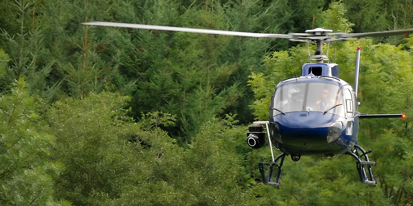
Aerial Photos
Hand-held or Mounted OpTions in Tulsa
We will help you get the right equipment for your aerial photography project! Call 1-866-826-4826 today to get a fast, free quote.
The Most Options for Photography
The spectacular and diverse landscapes of Oklahoma are optimally captured through professional aerial photography, providing perspectives unattainable from the ground. Tulsa Helicopter Charters provides specialized aerial photography charters meticulously designed to translate your precise visual concepts into stunning reality. We are dedicated to offering our clients premier photographic opportunities across the Tulsa metropolitan area and wider Oklahoma region, emphasizing both exceptional quality and cost-effectiveness. For projects requiring dynamic handheld capture, many available helicopters can be configured for door-off operations. For projects demanding superior stability and precision, advanced gyro-stabilized camera mounts are readily available to ensure the highest fidelity and sharpest imagery, enabling comprehensive realization of your creative vision.
Superior Service
Every one of our customers gets a dedicated helicopter expert to assist with flight plans, tech loadouts, production logistics, project schedules, and other demands.
Over 500 Aircraft
Our network of direct air partners extends well beyond Tulsa, Oklahoma. This allows us to offer a wide range of solutions for even the most sophisticated projects.
The Best Equipment
From high-tech sensors like LiDAR, FLIR, and GIS to HD cameras and movie production gimbals, we're here to make your job as easy as possible.


